

Satellite Map ( Non Cellular Data Offline Map And GPS Logger ) app for iPhone and iPad
Developer: KATO GIKEN, K.K.
First release : 19 Apr 2015
App size: 1.46 Mb
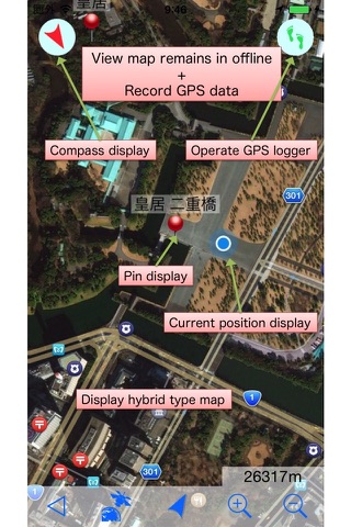
Displays the satellite photo type of map without cellular data (offline). Normal map can also be displayed.
Therefore, without the cellular data costs in mind, you can view the map.
Record the movement route even in the background by the GPS logger function.
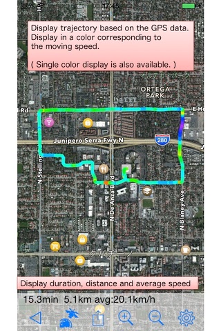
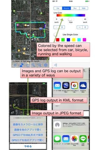
This app can display the trajectory of GPS logs colored with movement speed on the map.
GPS logs can be output as a file in KML format, is available in other map apps.
Attractions, hotels, station, landmark you want to visit, you can display the pin on the map. (Up to 100)
With that you download and save the destination of the map in the WiFi connection ready,
You can display the map without a cellular data on the go. (Map I can save up to 30 areas)
More than 600 position informations (latitude, longitude) of country, region, city, tourism, airport, station
of the world have been registered in advance, you can get immediately the map/pin.
Grasp of local makes it easier for in addition to those of the standard,
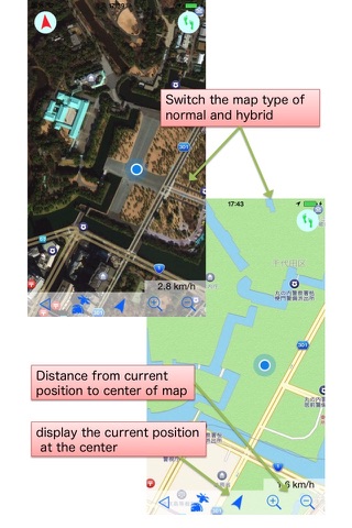
type of satellite photos (aerial photographs) can be displayed.
It is possible to adjust the direction and the actual direction of the map by the compass display.
(Please be used in conjunction there is unstable if, and other means compass display.)
View in real time the distance to the centre of map from the current position,
or displays moving speed.
The ability to view the map without cellular data, even iPad Wi-Fi-only connection and iPhone / iPad
that is left over and model changes You can take advantage of.
(It is not possible to display You are here because there is no GPS functions iPad Wi-Fi-only connection Note)
It is effective even if you go to places like the out-of-service.
(For climbing, hiking, and skiing)
And how to use, please refer to
http://www.katogiken-app.mimoza.jp/satellitemap/
Note:
Continued use of GPS running in the background can dramatically decrease battery life.
Restrictions:
Zoom map only three steps
Full screen map of acquisition (one time) + 3 times (9 times the area) + 7 times (area 49 times)
Map of the part that you scroll beyond the range map previously obtained (Offline map) can not be displayed.
You do not have the current position in the case of models that can not be obtained current position without
the GPS function as iPad Wi-Fi model.